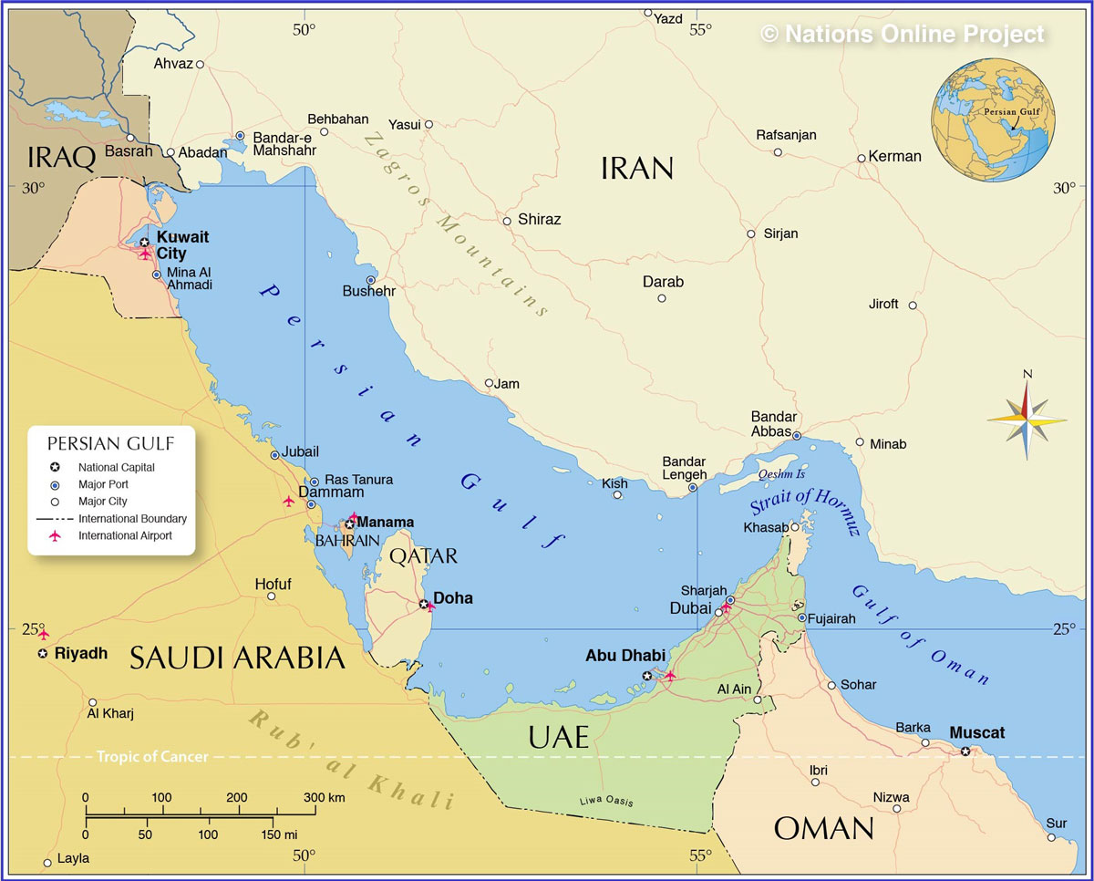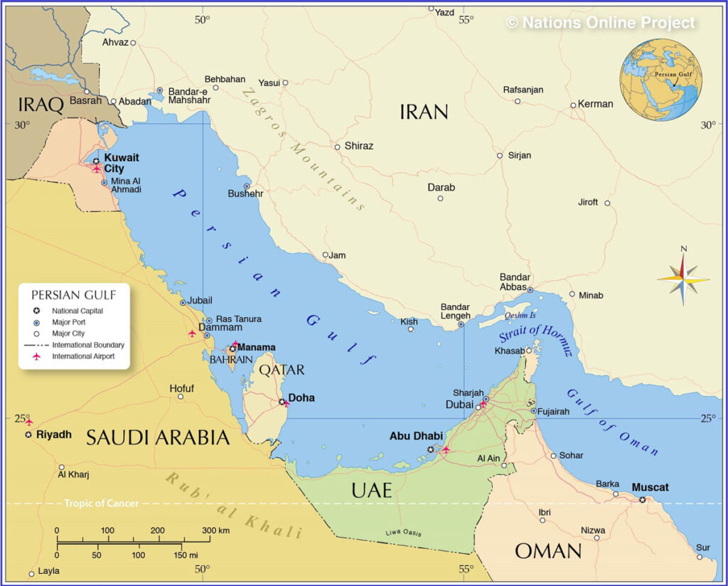
The Persian Gulf (Khalij-e Fars) is one of the world’s most strategically significant bodies of water. It has served as a center for civilization for thousands of years. A conduit for trade, cultural exchange, and crossroads of geopolitical clashes for millennia. Nestled between the Arabian Peninsula and the southwestern shores of Iran, the Persian Gulf spans approximately 251,000 square kilometers and has been a focal point of human activity since ancient times in areas such as Hormuz Island.
The Persian Gulf is bordered by eight distinct countries, each contributing to the region’s rich cultural tapestry and strategic significance. They include Iran, Iraq, Kuwait, Saudi Arabia, Bahrain, Qatar, UAE, and Oman.
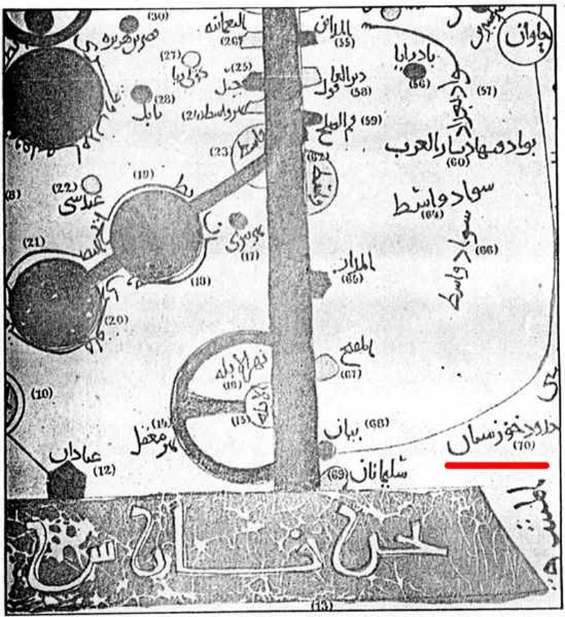
Historical Map of the Persian Gulf
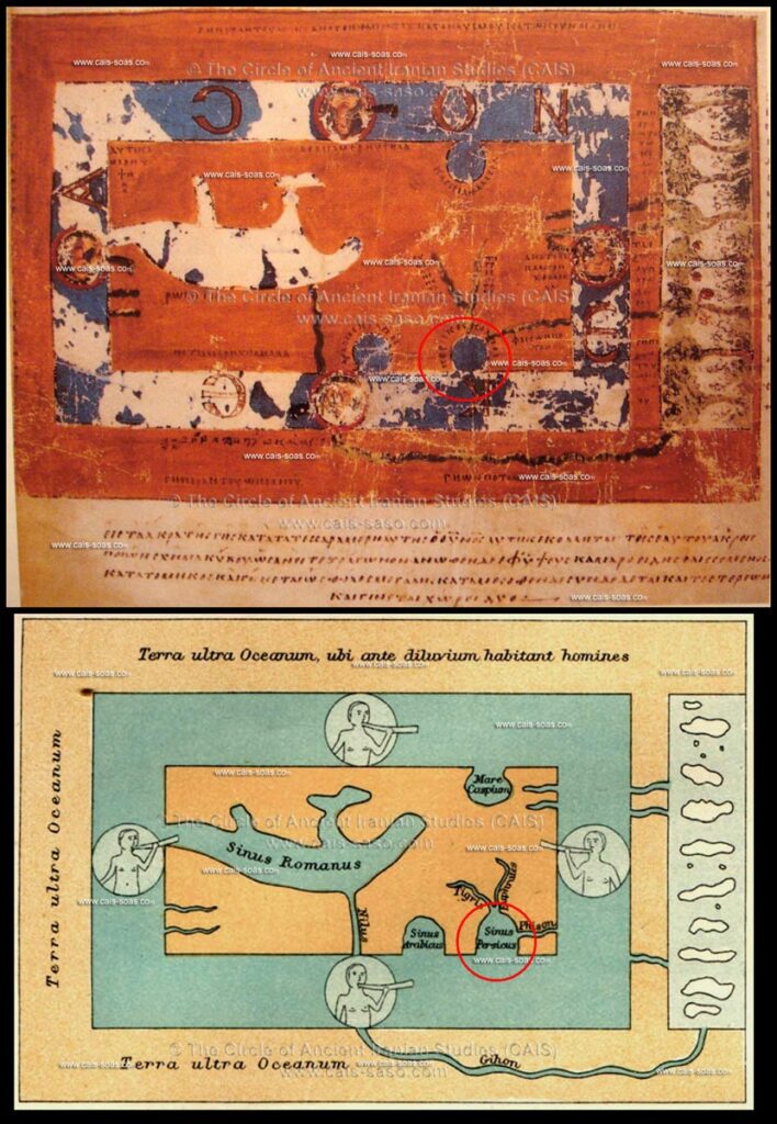
The earliest descriptions of the Persian Gulf were found in the Mesopotamian inscriptions from 500 BCE, describing Darius the Great. It was considered a focal exchange point between the ancient civilizations of Elam, Mesopotamia, and the Indus Valley.
The oldest surviving depiction of the Persian Gulf as Sinus Persicus dates back to the above Byzantine map from the 6th century CE. There are reconstructions of a map by an anonymous cartographer from Ravenna that depict the Persian Gulf in 700 CE.
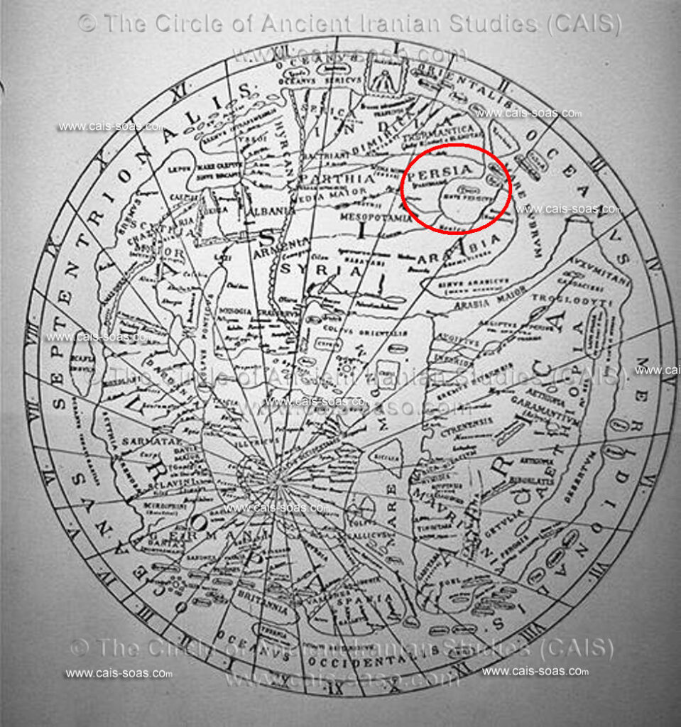
The next cartographer to depict the Bahr Fars (Persian Sea) dates back to 900 CE, in a map by Istakhri. Other Islamic maps of the same era also depict the body of water with the title Bahr Fars.
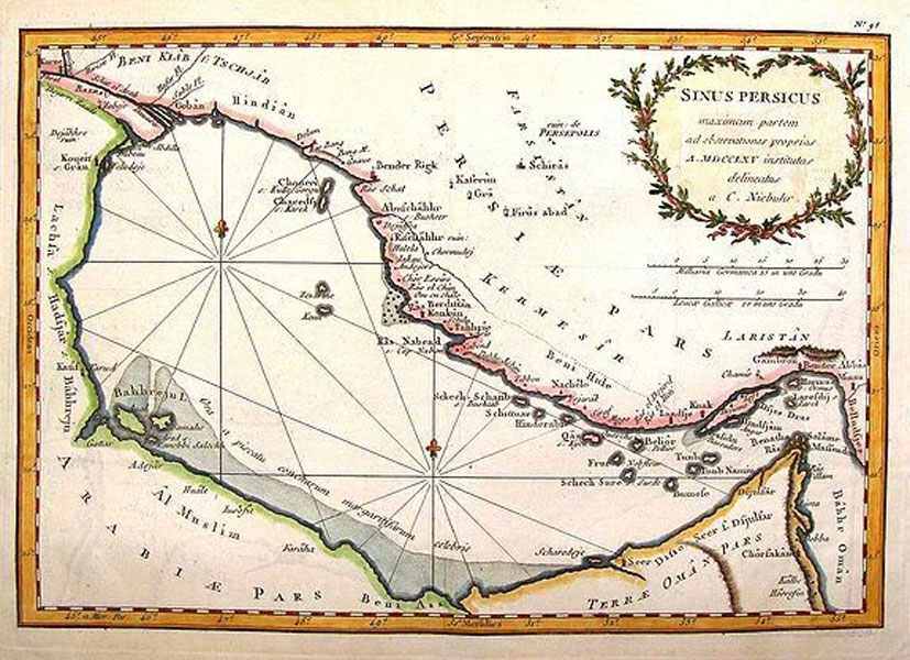
In the year 1565, the cartographers of the Renaissance period created a new map (shown below) depicting the Sinus Persicus, or Maximam Partem ad Observationes Proprias a MDXXLXV.
Geological Map of the Persian Gulf Basin
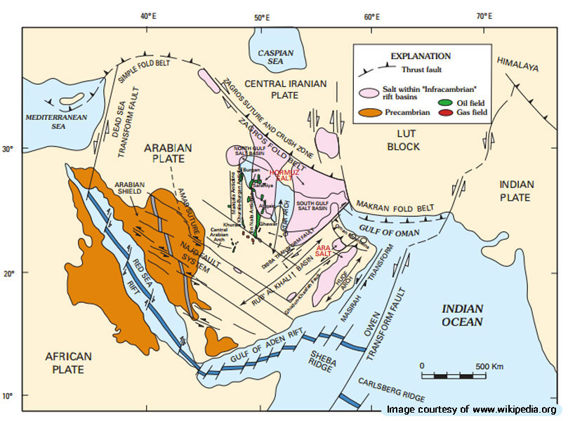
The Persian Gulf basin formed in the Cenozoic age around 66 million years ago with the subduction of the Arabian tectonic plate under the Zagros Mountains. With the rising sea levels following the Holocene glacial retreat 15,000 years ago, the sea levels started rising in the basin, eventually leading to the current rise of 4.3 mm per year.
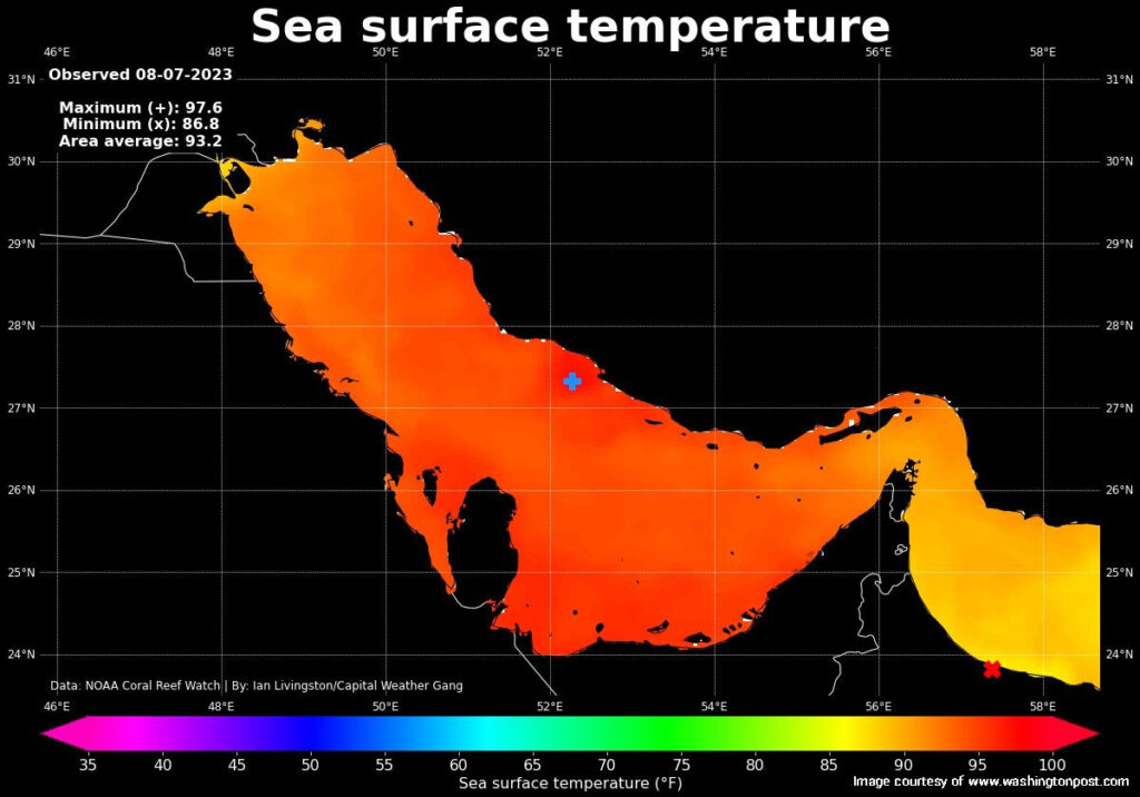
Climate Map of the Persian Gulf
The Persian Gulf region experiences a predominantly arid climate characterized by extreme temperatures and minimal rainfall. The climate patterns of the Persian Gulf form the environmental challenges and the living conditions of its inhabitants. Temperature variations can significantly impact marine life. Warmer waters may lead to coral bleaching, especially around the maximum temperature areas. Cooler regions might support a different set of marine species more resilient to lower temperatures.
- Maximum temperature: 97.6°F (marked with a red “x”)
- Minimum temperature: 86.8°F (marked with a blue “+”)
- Area average temperature: 93.2°F
Topography Map of the Persian Gulf
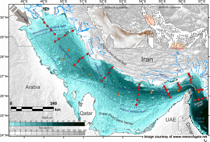
The topography map of the Persian Gulf reveals the varied landscape both above and below the water. This map highlights the intricate details of the region’s elevations and depths, providing a comprehensive understanding of the physical features that define the Gulf.
Coastal Features:
Shoreline: The Persian Gulf’s coastline is marked by sandy beaches, rocky shores, and expansive salt flats known as sabkhas. These features vary significantly across the different countries bordering the Gulf.
Deltas and Estuaries: Major rivers such as the Shatt al-Arab in Iraq contribute to the formation of deltas and estuaries, which are crucial for local biodiversity and support vibrant ecosystems.
Bathymetry Map of the Persian Gulf
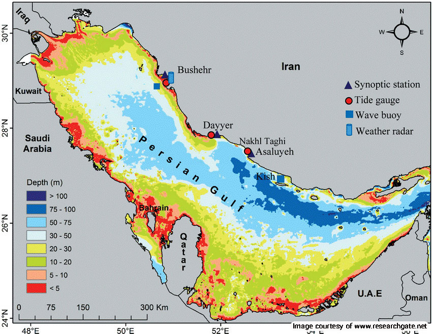
A bathymetry map provides a detailed representation of the underwater topography of the Persian Gulf, showcasing the depths and contours of the seabed. The Persian Gulf is a shallow marginal sea of the Indian Ocean, with depths rarely exceeding 50 meters, although some areas near the entrance and close to the Persian shore can reach depths of over 60 meters.
Key Features:
- Shallow Waters: The majority of the Persian Gulf is relatively shallow, with an average depth of around 30 meters.
- Deeper Areas: The deepest parts of the Gulf are found near the Persian coast, with depths reaching up to 70 meters.
- Submarine Shelf: The Gulf is bordered by a narrow submarine shelf on the western side, with deeper troughs floored by marly sediments.
- Islands and Shoals: Numerous islands and shoals dot the Gulf, some representing geological features like folds or salt plugs, while others are depositional features composed of unconsolidated sediments.
Persian Gulf Precipitation Map
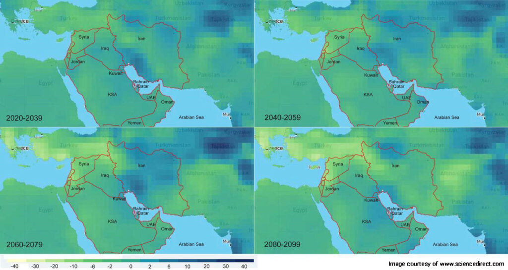
In the long-term projections, the Persian Gulf region demonstrates significant warming. The yellow areas on the map highlight the intensity and spread of the temperature increase, covering larger parts of the Gulf. These changes will likely exacerbate existing environmental challenges, such as water scarcity, heat waves, and impacts on marine life.
Implications for the Persian Gulf: Understanding these projections is crucial for planning and adaptation strategies. With the anticipated rise in temperatures, there is an urgent need for regional cooperation to address the effects of climate change. Initiatives might include enhancing cooling infrastructure, optimizing water management, and implementing sustainable development practices.
Map of the Persian Gulf Islands:
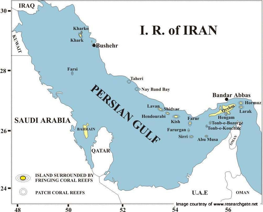
Iran
- Qeshm Island: The largest island in the Persian Gulf, known for its unique geological formations and diverse wildlife.
- Kish Island: A popular tourist destination with beautiful beaches, shopping centers, and recreational activities.
- Hormuz Island: Famous for its colorful soil and historical significance.
- Hengam Island: Known for its clear waters, dolphins, and traditional fishing villages.
- Lavan Island: An important oil-exporting port with beautiful beaches.
- Larak Island: Known for its strategic location and beautiful coral reefs.
- Kharg Island: A significant oil export terminal with historical sites.
- Abu Musa: Disputed territory, home to fishing and traditional settlements.
- Greater Tonb (Tonb-e Bozorg): Known for its red soil and rugged terrain.
- Lesser Tonb (Tonb-e Kuchak): Smaller and less elevated, primarily used for military purposes.
- Shidyar, Farurgan Farur, and Sirri
United Arab Emirates
- Sir Bani Yas Island: A nature reserve home to various wildlife species and luxury resorts.
- Delma Island: An island with a rich history and traditional Emirati culture.
- Al Reem Island: A rapidly developing residential and commercial area in Abu Dhabi.
Bahrain
- Muharraq Island: The third largest island in Bahrain, hosting the Bahrain International Airport and several cultural sites.
- Hawar Islands: An archipelago known for its wildlife, including rare bird species and marine life.
- Sitra Island: An industrial hub with several oil and gas facilities.
Saudi Arabia
- Farasan Islands: An archipelago in the Red Sea, known for its pristine beaches and biodiversity.
- Jazirat Al Arab: A small island known for its historical significance and archaeological sites.
Qatar
- Pearl-Qatar: An artificial island with luxurious residential and commercial developments.
- Al Safliya Island: A popular spot for boating and water sports.
Kuwait
- Failaka Island: An island with rich archaeological sites and historical significance.
- Boubyan Island: The largest island in Kuwait, primarily a nature reserve.
Oman
- Masirah Island: Known for its beautiful beaches and nesting sites for sea turtles.
- Daymaniyat Islands: A protected area with rich marine biodiversity, popular for diving and snorkeling.
Mountain Ranges:
- Zagros Mountains: This extensive mountain range stretches along the Iranian coast, influencing the climate and hydrology of the region. The mountains rise sharply from the coastal plain, creating a dramatic backdrop.
- Jebel Akhdar: In Oman, the Jebel Akhdar range provides a stark contrast to the flat coastal plains, with its rugged terrain and high peaks.
Environmental Map of the Persian Gulf
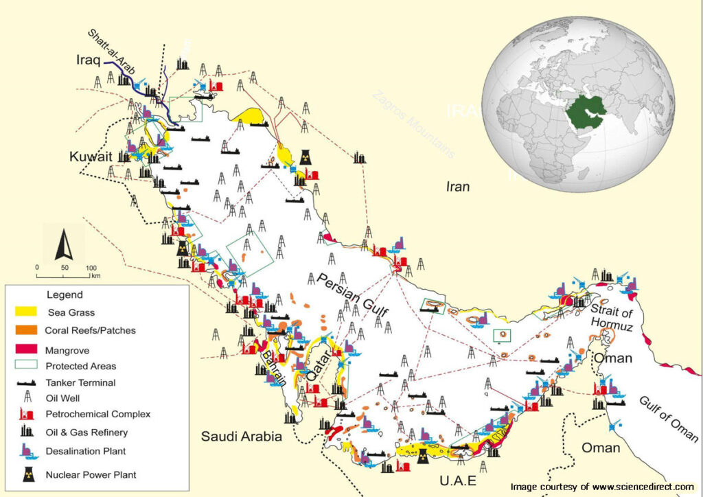
The environmental map of the Persian Gulf provides a detailed overview of various ecological and industrial features along the coastline and surrounding waters. The map highlights key environmental elements such as seagrass, coral reefs/patches, mangroves, and protected areas. Additionally, it marks significant industrial installations including tanker terminals, oil wells, petrochemical complexes, oil & gas refineries, desalination plants, and nuclear power plants.
Key Features:
- Sea Grass (Yellow): Areas with sea grass are marked in yellow, indicating regions where this important marine habitat is found. They provide crucial habitats for marine life, including fish, crustaceans, and endangered species like dugongs and sea turtles. They also help stabilize the seabed and improve water quality by filtering pollutants.
- Coral Reefs/Patches (Orange): Coral reefs and patches are shown in orange, highlighting the locations of these vital ecosystems. The reefs are biodiversity hotspots, supporting a wide range of marine species. They also act as natural barriers, protecting coastlines from erosion and storm surges. The health of coral reefs is vital for fishing industries and tourism.
- Mangroves (Red): Mangrove areas are marked in red, showcasing regions where these coastal forests thrive. Mangroves serve as breeding grounds and nurseries for fish and other marine life. They play a critical role in protecting shorelines from erosion and storm damage. Additionally, mangroves sequester carbon, helping to mitigate climate change.
- Protected Areas (Green Outline): Protected areas are outlined in green, indicating zones designated for environmental conservation.
| Country | Protected Area | Description |
| Iran | Hara Biosphere Reserve (Qeshm Island) | UNESCO-designated reserve with extensive mangrove forests and diverse marine life. |
| Dayer-Nakhiloo National Park | Rich biodiversity and coastal ecosystems. | |
| Bamu National Park | Features unique desert and mountainous landscapes. | |
| Saudi Arabia | Jabal Shada Nature Reserve | Known for its unique geological formations and diverse flora and fauna. |
| Majami’ al-Hadb Protected Area | Recognized for its coastal and marine habitats. | |
| Raydah Natural Reserve | Supports various species of plants and animals. | |
| United Arab Emirates | Wadi Wurayah National Park | Freshwater springs and diverse wildlife. |
| Sir Bani Yas Island | Hosts a wildlife reserve and conservation programs. | |
| Oman | Daymaniyat Islands Nature Reserve | Includes several islands with rich marine and bird life. |
| Al Hajar Mountains | Known for its unique mountainous ecosystems and biodiversity. |
Persian Gulf Natural Resource Map
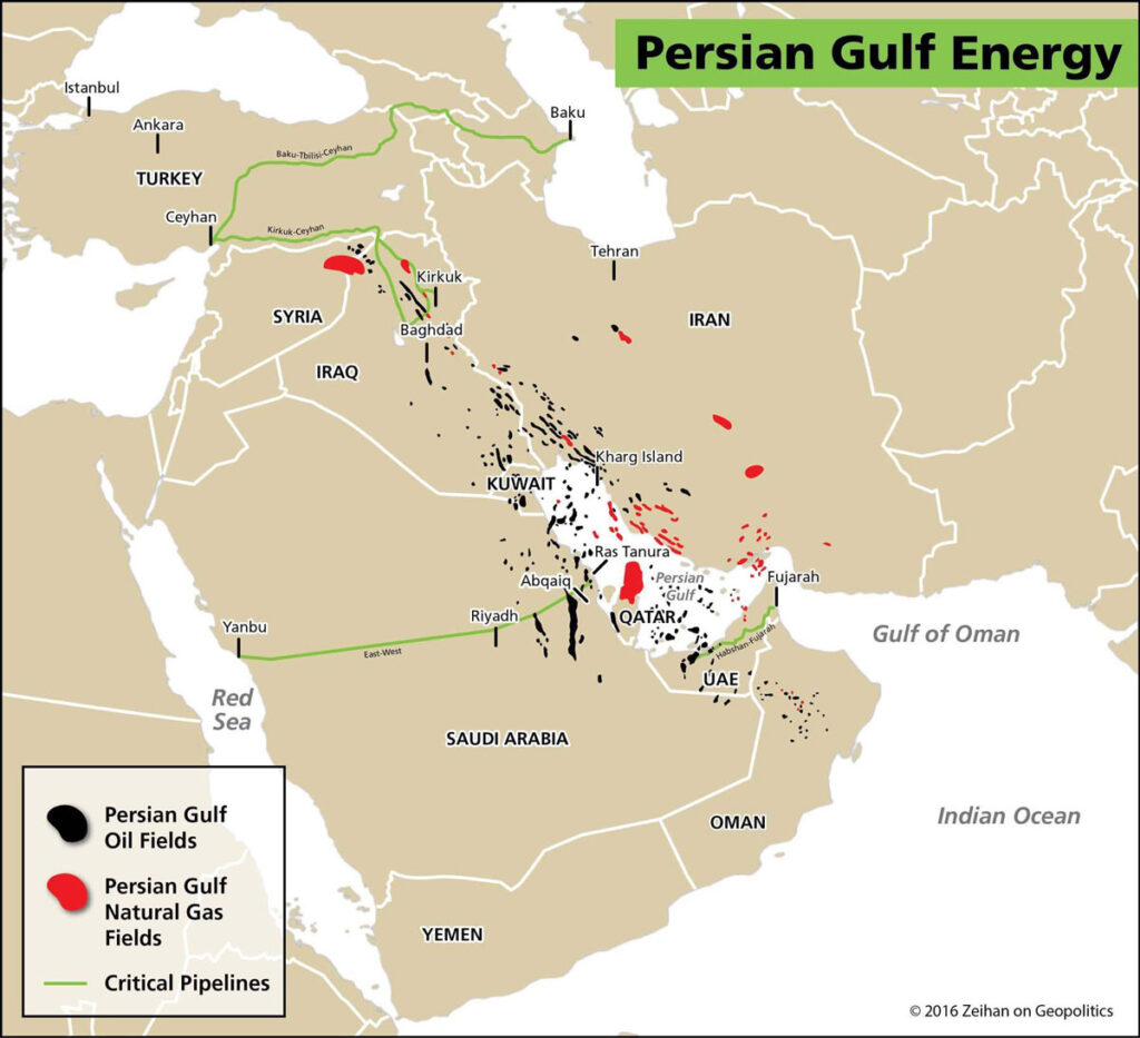
The Persian Gulf is a region rich in natural resources, and the map provides a comprehensive overview of the key resources found in this strategic area. This map highlights the locations of major oil and gas fields, as well as significant mineral deposits and fishing grounds.
Oil and Gas Fields:
Key Locations: Major oil fields such as Ghawar (Saudi Arabia), South Pars/North Dome (Iran/Qatar), and Burgan (Kuwait) are prominently marked on the map. These fields contribute significantly to global energy supplies and the economies of the Gulf countries.
Frequently Asked Questions About the Persian Gulf Map
If you have any other questions about the map of the Persian Gulf, please let us know in the comments. We will respond as soon as possible.
What is the Persian Gulf?
The Persian Gulf is a body of water in Western Asia, located between the Arabian Peninsula and the southwestern shores of Iran. It spans approximately 251,000 square kilometers and is bordered by eight countries: Iran, Iraq, Kuwait, Saudi Arabia, Bahrain, Qatar, UAE, and Oman.
Why is the Persian Gulf significant?
The Persian Gulf holds immense strategic, economic, and environmental importance. It is a critical route for global oil transportation, rich in biodiversity, and home to numerous historical and cultural sites.
How is the climate in the Persian Gulf?
The Persian Gulf region experiences an arid climate characterized by extreme temperatures, particularly in the summer, and minimal rainfall. Winters are mild, and seasonal variations can include sandstorms and high humidity.
What natural resources are found in the Persian Gulf?
The Persian Gulf is rich in oil and natural gas reserves, which are crucial to the global energy market. It also has significant mineral deposits, fishing grounds, and other marine resources.
Are there any protected areas in the Persian Gulf?
Yes, there are several protected areas aimed at conserving the unique marine and coastal ecosystems. Examples include the Hara Biosphere Reserve in Iran, Wadi Wurayah National Park in the UAE, and the Daymaniyat Islands Nature Reserve in Oman.


