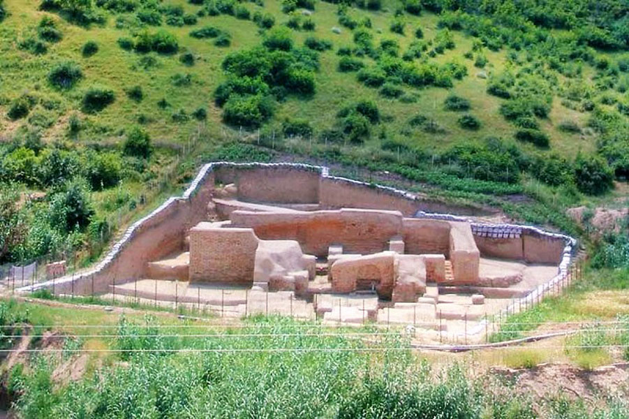
Walls have always been one of the most important defense elements of any city to block enemies. There are famous walls in the world. The largest defense wall in the world is called the Great Wall of China, followed by the White Wall of Germany. The third one is the Great Wall of Gorgan (Iskander’s Great Wall, the Red Wall), which is registered as a national monument in Iran.
This wall is named Red Snake in old texts. Also, its location has been very strategic. Now, almost all of this wall is gone, and only small parts of it have remained, which are buried under the soil.
Other names of this structure are Dehestan Wall, Gomishan Wall, Tajanbar, Red Snake, Iskander Great Wall, Iskander Dam, Anoushirvan Dam, Firouz Dam, Gorgan Defense Wall, Qezal Elaq, Qezal Alang and Alan (in the Turkmen language) and Red Wall. The names of Dehestan and Gomishan are given to it because of the location of this wall.
The Great Wall of Gorgan as Mentioned in Historical Writings
The Great Wall of Gorgan has been mentioned in many historical writings. Among them:
- 864 AD: Balazri in the conquest of Al-Baldan
- 903 AD: Ibn Faqih in Al-Baldan
- 912 AD: Ibn Khurdadbah in Masalak and Al-Mamalek
- 982 AD: The boundaries of the world from the East to the Maghrib
- 10th century AD: Ferdowsi in Shahnameh
- 11th century AD: Thaalabi, the pride of Persian kings and Sirham
- 1051 AD: Gardizi, Zain al-Akhbar
- 1208 AD: Mohammad Najib Bakran, Jahannameh
Some of the books of contemporary historians who have written about the Great Wall of Gorgan:
- Marquardt in the cities of Iran
- Rabino in his travelogue of Tabaristan and Estrabad
- Roman Girshman in Iran from the beginning of Islam to the Sassanids
- Saeed Nafisi in the history of the civilization of Sassanid Iran
- Masih Zabihi in Estrabad Name
- Asadullah Moeini in the historical geography of Gorgan and Dasht
- Amin Goli in the political and social history of Turkmens
- Lestrange in the lands of the Eastern Caliphate
Dimensions and Sizes of the Great Wall of Gorgan
There are various figures about the length of this structure. Some historians have estimated the length of this wall up to one hundred and eighty Farsang (old Iranian unit of measurement equal to 6.24 km). Many believe that this wall is part of a larger wall.
The Great Wall of Gorgan has a length of about 200 km and a width between 2 and 10 meters. Also, its possible height was 6 to 8 meters. Its main material is red brick with dimensions of 40X40X10 cm with lime mud mortar and in some places Saruj (traditional Iranian cement).
Also, this wall has got beautiful decorations with plaster mortar in some places. Along its route, this work has related facilities such as moats, forts connected to the wall, brick kilns, earthen dam, water supply channel, and the castles of cities adjacent to the wall on the north and south sides of the Gorgan wall. Also, in terms of fortifications and defense structure, it is more advanced than the Great Wall of China.
Constructional Materials Used in the Wall of Gorgan
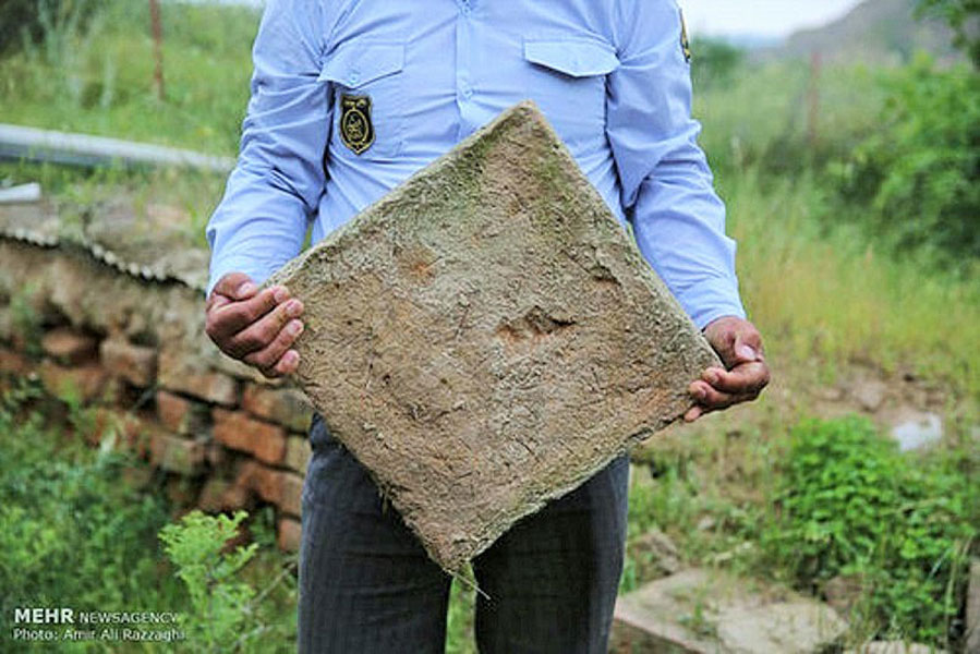
There are various predictions about the type of other materials in the wall. Some consider it stone and lead, others consider it brick and lime, brick and plaster, stone and plaster, marble and baked clay. A part of the wall has been unearthed in the village of Gogjeh (north of Kalaleh). This part is made of big bricks.
Researches by archaeologists from the universities of Edinburgh and Durham show that tens of millions of bricks were used in the construction of this wall. There were many kilns and brick-making workshops along the wall and in close proximity to it. This issue indicates a very large industrial workshop for the construction of the Great Wall of Gorgan. According to estimates, 30,000 soldiers could be stationed along the wall.
The Reason for the Construction of this Huge Ancient Wall
Human life throughout history has always been affected by accidents. Therefore, solutions have been devised to deal with these risks. Hundreds of years ago, many hazards of natural or human origin were able to destroy the lives of many people. Also, these dangers could remove signs of life from an area.
Based on this, the need to observe preventive measures to protect people from possible dangers has always been taken into consideration. The Great Wall of Gorgan is one of these arrangements for non-functional defense.
The Geographical Location of the Wall
The Great Waal of Gorgan starts from Kamesh Tepe beach, south of Atrak River and north of Turkmen Port. But the end is not exactly clear. The mouth of the Gorgan River, Khoja Ler village, Glidagh mountains or Aliabad Katul mountain peak are one of the destinations of the Gorgan Great Wall.
This Great Wall starts from the Caspian Sea in the Gomishan area and continues to the Golidagh Mountains in the northeast of Kalaleh. The railway line of Gorgan to Central Asia cuts a part of the north and south part of the historical wall of Gorgan. Therefore, this wall is divided into two halves.
In terms of climatic conditions, this wall is located in the mountainous and vast plains of Gorgan in the current Turkmen Sahra region. Gorgan River is known as the longest river in Golestan province. The direction of this river is east-west and it is located along the southern side of the Gorgan wall. Therefore, it played an important role in the construction of the Great Waal of Gorgan.
The Historical Background of the Wall
Most historians consider Anushirvan, the Sassanian King, the founder of this wall. In some other sources, the beginning of the construction of this structure is attributed to Yazdgerd I (another Sassanian king) and its completion to Anushirvan. It is agreed that this wall was built to prevent the invasion of the desert tribes.
Many experts believe that the historical wall of Gorgan was built at the same time as the Great Wall of China. Also, both of them are made to deal with a group of attackers called Hephthalites. Ibn Esfandiar, the father of Mazandaran history, and Rabino, the western writer of the Qajar period, attributed this wall to Farkhan the Great.
Archaeologists estimated the age of the wall to the 5th and 6th centuries AD (Sasanian period) by taking samples and testing the remaining ashes and coals. At that time, the Sassanid Empire had constant wars with the Eastern Roman Empire.
Also, the residents of this region from Iran were facing the threat of Huns and other northern tribes from the north. Therefore, the great wall of Gorgan could block the penetration of these tribes into Iran. Therefore, the huge structure of the Gorgan wall was created between the Caucasus mountains and the coastline of the Mazandaran sea.
Pirouz, the Sassanid king, spent some time in the Gorgan region between 459 and 484 when he was fighting the White Huns. So probably he or another Sassanid king (before or after him) built this wall. Their goal was to protect the fertile plain of Gorgan as a strategic area.
The forts or barracks of the Great Wall of Gorgan show that it was active for at least a century after it was built. Signs of the presence of soldiers can be seen in it. But after that, it was abandoned for certain reasons.
Among the reasons for the abandonment of these defense facilities could be the need for more soldiers to be present in the battle with the Byzantine Empire or to resist the Arab attack.
This wall is longer than Hadrian’s Wall. Hadrian’s Wall was built by Emperor Hadrian on the border between England and Scotland. Also, this massive defensive wall is more than a thousand years older than most parts of the Great Wall of China. It took 90 years to build this wall. The Great Wall of Gorgan used to be the longest brick wall in the world once.
Iranian engineering during the Sassanid Empire competed well with Roman Empire engineering. It has even exceeded it in some cases.
The photo of this wall was first recorded by American archaeologist Eric Schmidt. In 1936 and 1937, Mr. Schmidt photographed the ancient places of Iran by plane. In the Gorgan region, he saw a red wall that stretches from the Caspian Sea to the Glidagh Mountains. He took photos of this wall and these photos became a document for the research of Iranian and foreign archaeologists on this wall.
Derbent Caspian Gate
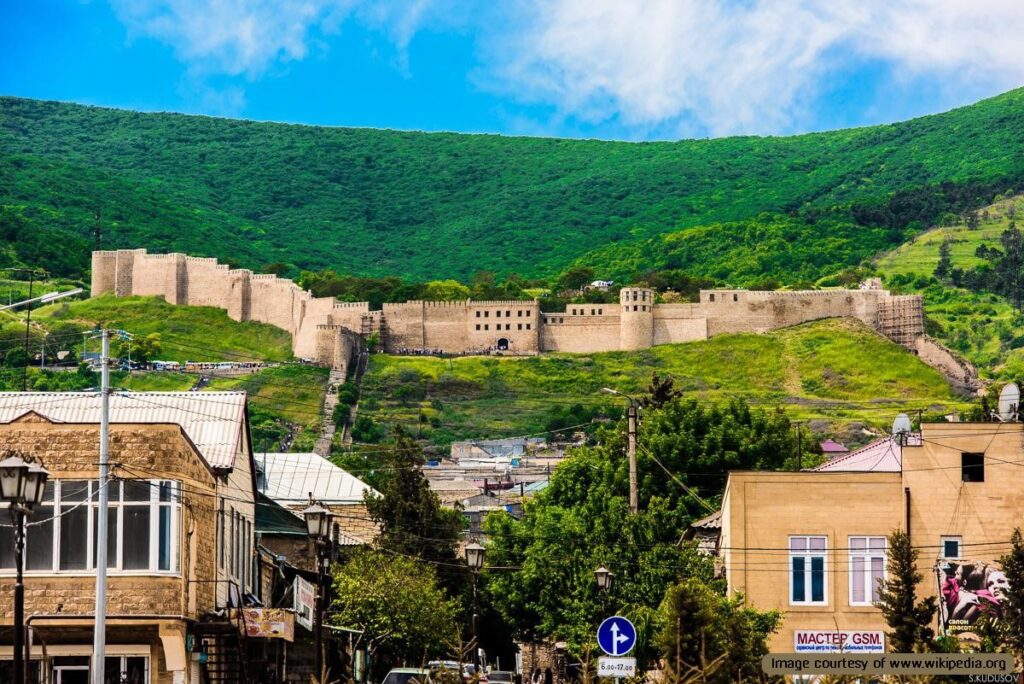
The Derbent Caspian Gate, also known as the Caspian Gates or the Gates of Alexander, is a historic Sassanid structure built by Khosrow I. It is believed that the Derbent fortifications were built in symmetry with the Gorgan wall to protect the western shores of the Caspian Sea. Located in the city of Derbent in present-day Dagestan, Russia, the historical fortifications are nestled between the Caspian Sea and the Caucasus Mountains.
In the past, it has served as a gateway between the Eurasian steppes to the north and the Iranian plateau. The fortifications at Derbent include extensive walls and gates, and have played a vital role in the defense and control of northern Iran throughout history.
Historical Significance
The significance of the Derbent Caspian Gate dates back to ancient times. The Achaemenid Empire (550–330 BC) recognized the strategic importance of this pass and fortified it to protect against incursions from nomadic tribes.
During the Sassanid Empire (224–651 AD), the fortifications at Derbent were extensively developed by Khosrow I. The Sassanids constructed a citadel, and a series of walls and gates, collectively known as the “Caspian Gates,” to guard against invasions by the Huns and other northern tribes.
Architecture and Layout
Naryn-Kala Citadel: The centerpiece of the fortifications is the Naryn-Kala Citadel, a massive fortress situated on a hill overlooking the city. This citadel served as the last line of defense and a command center.
Twin Long Walls: Extending from the citadel to the Caspian Sea, these walls created a formidable barrier. The walls are approximately 20 meters high and 3 meters thick, stretching for about 40 kilometers. They effectively blocked the narrow pass between the Caspian Sea and the Caucasus Mountains.
Mountain Wall (Dagh-Bary): This wall runs from Derbent to the foothills of the Caucasus Mountains, providing an additional layer of defense against invasions from the north.
Towers and Bastions: The walls are punctuated by numerous towers and bastions, which provide vantage points for surveillance and defense. These structures allowed defenders to monitor and repel attackers effectively.
Gates and Gatehouses: Strategically placed gates controlled access through the walls. These gates were heavily fortified and served as critical points for defense and trade regulation.
Double Walls: In some sections, the fortifications included double walls, adding an extra layer of defense. This design made it more difficult for attackers to breach the defenses.
Are Derbent Fortifications The Gates of Alexander?
The Derbent Caspian Gate is often associated with the legendary Gates of Alexander. According to various historical and religious texts, Alexander the Great constructed a massive wall or gate to defend civilized lands from northern barbarian tribes such as Gog and Magog.
While the exact historical and geographical specifics are shrouded in myth and legend, the Caspian Gates at Derbent are frequently linked to this legend due to their strategic location and formidable fortifications.
Fortifications and Strategic Importance
The fortifications at Derbent consist of extensive walls that stretch from the Caspian Sea into the Caucasus Mountains. These defenses were designed to control the narrow pass and protect against northern invasions. The main gate, often referred to as the Caspian Gate, was a critical point for controlling access through the pass. The fortifications included multiple layers of defense, towers, and strategically placed gates to monitor and control movement.
Derbent’s strategic location also facilitated cultural exchanges between Greek, Persian, and local cultures. This interaction was a hallmark of the Hellenistic period, where Greek culture blended with local traditions across Alexander’s former empire. Additionally, Derbent’s position on the Silk Road enhanced its economic importance. As a gateway for trade between Europe and Asia, control of Derbent meant influence over one of the major trade routes of the ancient world.
Derbent Caspian Gate in Later Periods
Throughout the medieval period, Derbent remained a key military and trade route, reflecting its enduring strategic importance. During the Byzantine-Persian wars, control over Derbent was contested, and the Arabs eventually conquered the city in the 7th century, further fortifying it and recognizing its strategic value. The fortifications at Derbent continued to play a crucial role in the defense of the region well into the medieval period.
The Derbent Caspian Gate stands as a testament to the strategic and historical significance of this narrow pass between the Caspian Sea and the Caucasus Mountains. From ancient empires to medieval kingdoms, the fortifications at Derbent have played a vital role in the defense and control of this crucial gateway. The blend of myth, legend, and historical fact surrounding the Caspian Gates adds to the rich tapestry of Derbent’s history, making it a fascinating subject for further exploration.
Visiting the Great Wall of Gorgan
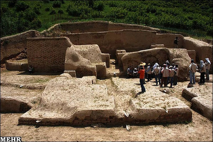
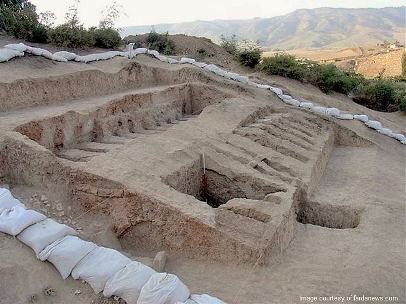
Due to the destruction and burial of the Gorgan wall under soil and sediments over time, it is difficult for tourists to access it. But four points (excavation workshop) along the path of the Gorgan wall have been excavated by archaeologists. These four points can be visited (find the map of these points on the relevant specialized site) and to visit the Great Wall of Gorgan, it is enough to visit one of them:
- Yasaqalq exploration workshop, Yasaqalk Bala village, Kalaleh city
- Qara Dib exploration workshop, Kasr village, Kalaleh city
- Gargar exploration workshop, Qara Yasar village, Kalaleh city
- Exploration workshop of Sari Su, Tamar village of Qaraqozi, Kalaleh city
“Destination Iran” recommends studying more about this wall to understand the climatic, historical, and geographical conditions of the region better. This will make your trip a conscious one. During your trip to this area, learn more about the tourist attractions of Gorgan.


